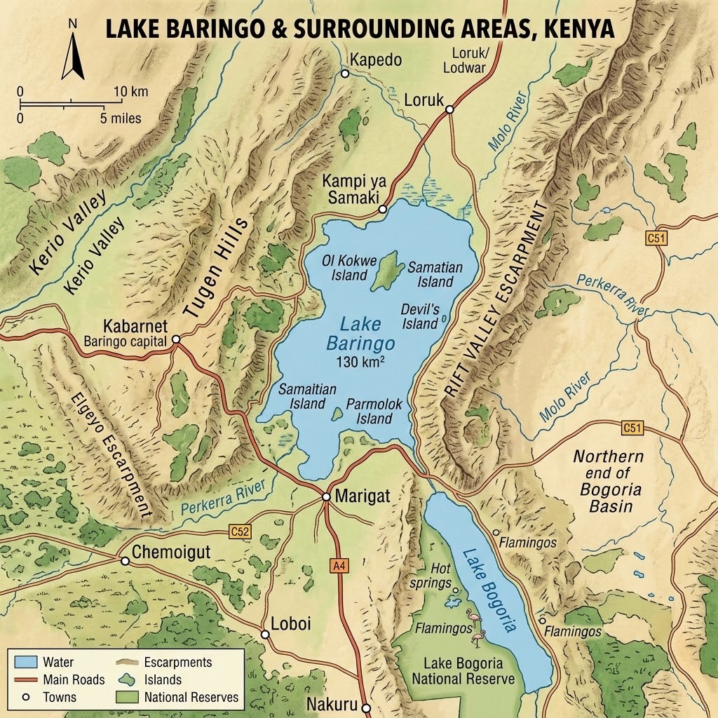
The impact of agricultural activities on the Lake Baringo ecosystem is significant, primarily driven by catchment degradation and chemical runoff. While the Stockholm Convention targets various persistent organic pollutants (POPs) to protect human health and the environment, it is important to distinguish the nature of these substances in the context of your concerns.
Agricultural Impact on the Lake Baringo Ecosystem
Lake Baringo is an arid, endorheic (closed) lake, making it highly sensitive to disturbances in its catchment area. Agricultural intensification has contributed to several ecological stresses:
- Catchment Degradation and Sedimentation: Agricultural expansion, deforestation, and overgrazing in the Baringo catchment lead to widespread soil erosion. This results in high levels of sedimentation and turbidity in the lake, which negatively impacts fish breeding areas, reduces native fishery productivity (e.g., Oreochromis niloticus baringoensis), and degrades overall water quality.
- Pollutant Runoff: Runoff from agricultural fields—transported by rain or irrigation—often carries pesticides, fertilizers, and sediments into the lake. These substances can lead to eutrophication and alter the aquatic microbial community structure, potentially disrupting the food web.
- Loss of Biodiversity: Habitats are fragmented due to agricultural encroachment into buffer zones and wetlands, leading to a loss of wildlife species and increased human-wildlife conflict as animals compete for dwindling water resources.
To address these environmental challenges, existing frameworks provide guidance for sustainable practices:
- Pesticide Management: Responsible use of pesticides involves acquiring only the quantities needed, avoiding contamination of water sources, and properly disposing of pesticide residues and empty containers.
- Waste Management: National environmental regulations stipulate that waste, including hazardous packaging from agrochemicals, must be disposed of in designated areas rather than in public places or water bodies.
- Climate-Smart Agriculture: Implementing climate-smart agricultural technologies can help mitigate emissions from agricultural practices and reduce reliance on harmful inputs while strengthening national food systems.
Ensuring adherence to the project-specific Environmental and Social Management Frameworks (ESMPs) is crucial. These frameworks are designed to mitigate adverse impacts by mandating soil management practices (e.g., using indigenous trees and grasses), promoting the use of safe alternatives (e.g., compost manure), and establishing monitoring protocols for water quality and soil health.
To support the Lake Baringo catchment restoration initiative and broader 3CA4R resilience building, sustainable land management (SLM) strategies can be categorized into five thematic pillars.
1. Green Infrastructure & Rangeland Restoration
These strategies focus on vegetative cover and the stabilization of ecosystems.
- Rangeland Rehabilitation: Implementation of commercial pasture plots and fodder banks (e.g., hay sheds) to provide sustainable livestock feed.
- Catchment Reclamation: Large-scale tree planting and nursery establishment, specifically using indigenous species, to stabilize soils and increase carbon sequestration.
- Agroforestry: Integrating trees into agricultural landscapes to improve soil fertility, provide shade, and reduce evaporation rates.
2. Brown & Grey Infrastructure (Soil and Water Conservation)
These interventions focus on managing runoff and water availability to reduce erosion and sedimentation.
- Micro-Rainwater Harvesting: Implementation of semi-circular bunds, terracing, and gully rehabilitation to slow down water runoff and promote infiltration.
- Water Harvesting & Storage: Construction of small-scale dams (earth/sand/rock dams), multi-purpose water pans, and underground water tanks/sub-surface dams in dry riverbeds.
- Solarized Water Systems: Drilling or rehabilitation of solar-powered boreholes to provide reliable, clean water while reducing reliance on expensive or unreliable power sources.
3. Sustainable Food Systems & Climate-Smart Agriculture
These strategies address the user’s concerns regarding pesticide use and food security.
- Integrated Pest Management (IPM): Replacing the unregulated use of harmful pesticides with IPM practices. This approach uses ecological, mechanical, and biological controls to manage pests, reducing chemical runoff into Lake Baringo.
- Organic Farming & Kitchen Gardens: Promotion of organic fertilizer use and household-based kitchen gardens to improve dietary diversity and food sovereignty.
- Climate-Smart Technologies: Scaling up the use of greenhouses, shade nets, and drip irrigation kits to optimize water use and crop yields in arid conditions.
4. Energy & Circular Economy
These interventions mitigate the impact of traditional fuel sourcing and waste mismanagement.
- Waste-to-Resource Models: Implementing biogas digesters that convert organic waste into clean cooking fuel and organic fertilizer. This reduces the need for firewood and manages livestock waste.
- Energy-Saving Technologies: Promoting the adoption of energy-saving cookstoves (improved jikos) and solar cooking to reduce forest degradation caused by charcoal and firewood production.
- Circular Economy Practices: Establishing models like Black Soldier Fly farming for animal feed formulation and hydroponics to create closed-loop systems.
5. Governance, Planning & Knowledge Transfer
Strategies to ensure community buy-in and sustainability.
- Participatory Land-Use Planning: Demarcating grazing routes and pasture zones in collaboration with community land management committees to prevent conflict and overgrazing.
- Intergenerational Knowledge Transfer: Establishing platforms that integrate traditional/indigenous knowledge (e.g., TILKIT tool) with scientific weather forecasting to strengthen early warning systems.
- Institutional Frameworks: Utilizing County Climate Change Funds (CCCF) and the Resilience Business Process to support community-led project management and monitor outcomes.
The effective implementation of Sustainable Land Management (SLM) strategies in the Lake Baringo ecosystem relies on a robust bridge between high-level planning and ground-level execution. The 3CA4R initiative uniquely addresses this by leveraging its core operational strengths—extensive field presence and advanced geospatial/database capabilities—to optimize the delivery of climate-resilient interventions.
1. Optimization through Real-Time Field Presence
3CA4R’s established field network serves as a critical feedback loop for project management. By maintaining a continuous presence, the project enables:
- Targeted Deployment: Utilizing on-the-ground knowledge of local topography and community dynamics to ensure that soil and water conservation structures (e.g., bunds, check dams) are sited in areas of highest degradation risk, rather than relying solely on generalized planning.
- Adaptive Management: Enabling immediate monitoring and rapid adjustment of restoration activities based on seasonal performance, ensuring that community-led initiatives remain responsive to the unique climatic variability of the Baringo region.
2. Data-Driven Decision Support through Mapping & Database Capacity
The integration of 3CA4R’s mapping and database capacity elevates SLM from manual application to precision intervention:
- Geospatial Targeting: Utilizing high-resolution mapping to identify priority hotspots for rangeland rehabilitation and catchment protection. This allows resources to be directed to where they will generate the greatest ecological impact, maximizing return on investment.
- Evidence-Based Monitoring: Maintaining a longitudinal database of ecological indicators allows 3CA4R to provide clear, quantified evidence of success—such as increased vegetation cover, soil moisture retention, and sediment reduction—which is essential for sustaining community engagement and securing long-term donor support.
- Knowledge Integration: Bridging the gap between scientific weather forecasting and traditional knowledge through a centralized platform, allowing stakeholders to make informed decisions regarding crop planting, grazing management, and early warning responses.
By combining the “boots on the ground” with “eyes in the sky” (GIS/mapping), 3CA4R transforms fragmented restoration efforts into a cohesive, measurable, and highly scalable model for resilience across the Lake Baringo catchment.
Wonderful job. In support of this wonderful journey of transforming our communities.